
Postmile Services
Browser Configuration
The Postmile Query Tool has been developed to work with most browsers. However, we can only support the most recent versions of these browsers, and parts of the tool's functionality may not work properly unless certain configurations are set in the browser. The following browsers have been tested:- Google Chrome (version 50.0+)
- Mozilla FireFox (version 46.0.1+)
Within each browser, ensure the following:
- Do not use "Compatibility" mode;
- Do not use graphics hardware acceleration (may not be compatible with Google Maps)
Welcome to the Postmile Services Postmile Query Tool
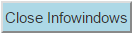
(This window can be dismissed by clicking the close button (![]() ) at right, and retrieved with the
) at right, and retrieved with the
![]() button above the top-right corner of the map.)
button above the top-right corner of the map.)
The Postmile Query Tool enables you to explore California's Linear Reference System. You can validate postmiles, convert between postmiles and geo-coordinates, and determine the state odometer associated with a postmile or geo-coordinate. This window enables you to view a collection of help pages explaining what this tool is and how to use it.
Help topics
- What is a postmile?
- Input Controls
- Controls & Map Markers
- How to: Point Mode
- How to: Line Mode
- Browser Configuration
- For more information
This page references data in the Postmile Web Service. The data is provided by the California Department of Transportation.
What is a Postmile?
A postmile is the way that a specific location on a state or federal route is specified within the Linear Reference System. In a linear reference system, locations are indicated by a distance along a route. Calibration postmiles represent locations that have been visually identified using aerial photography (National Agriculture Imagery Program—NAIP) and marked on the route. Other postmiles are interpolations between the calibration postmiles.
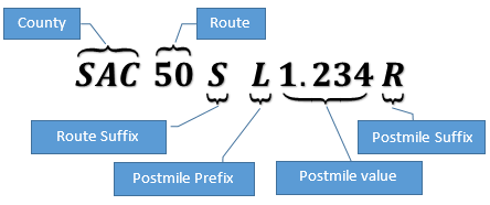
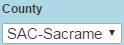
A postmile has three principal components: a County, a Route and a Postmile Value. The county is specified by its 2- or 3-letter county code (e.g., SAC for Sacramento, SB for Santa Barbara).
The route is identified by a 1-3 digit number, and a Route Suffix Code for those routes that require one.
The Postmile Value measures the distance, in miles, from the start of the route, or from the point at which the route enters the county. Thus, Postmile Values reset to zero each time the route crosses a county border. (Exception: when the border between two counties meanders, so that the route crosses the same border several times, the Postmile Value continues to increase as though no boundary had been crossed, and is marked by a Postmile Prefix Code of "D" — duplicate postmile at meandering county line.)
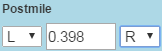
The Postmile Value may be accompanied by a Postmile Prefix Code (immediately before the postmile value) and/or a Postmile Suffix Code (immediately after the postmile value).
The Route Suffix Code, Postmile Prefix Code and Postmile Suffix Code are referred to as "qualifiers." Not all postmile specifications require their presence. However, where they are needed, they must be present for the postmile specification to be valid. Sometimes, two postmile specifications, representing two distinct geographic locations, differ only in whether or not a single qualifier is present. For example, the two postmiles ALA 84 23.133 and ALA 84 R23.133 differ only by the presence of the "R" Postmile Prefix Code, but they represent two locations along Route 84 separated by about 880 feet. (In other cases, two postmiles differing in one qualifier can represent locations 10 miles apart.) For this reason careful attention to correct qualifiers is necessary. The next page lists the values that these qualifier codes can take, and what they mean.
Statewide Odometer
The Statewide Odometer is an alternate indicator of position within the linear reference system. The Statewide Odometer measures the distance of the location along a route from the beginning of the route, without regard for county boundaries.
The Postmile specification uses measures that are local to each county (and Postmile Prefix codes) so that realigning a route (modifying the path that a route takes) has minimal impact on the specifications of locations downstream of the segment that was changed. This is important because of the cost to change all the physical postmile paddles that line the routes. In the Statewide Odometer, on the other hand, any change in the path of the route affects the odometer specification for all points downstream of the change, across the entire state.
Qualifiers in a Postmile Specification
Route Suffix
If a route suffix is needed, it will be one of the two letters:- S — Supplemental
- U — Unrelinquished
Postmile Prefix
If a postmile prefix letter is needed, it will be one of the following letters:- C — Commercial Lanes
- D — Duplicate postmile at meandering county line
- G — Reposting of duplicate postmile at route end
- H — Realignment of D Mileage
- L — Overlap postmile
- M — Realignment of R mileage
- N — Realignment of M mileage
- R — First realignment
- S — Spur
- T — Temporary connection
Postmile Suffix
Sometimes the two directions of a major route separate and follow substantially different paths. When this happens, the postmile is determined independently for each direction. In that case a postmile suffix letter is required to indicate the side of the road to which the postmile pertains:- L — Left (South on South-to-North routes, West on West-to-East routes)
- R — Right (North on Soutth-to-North routes, East on West-to-East routes)
Input Controls
Postmile  Fieldset


If checked, there is a row of controls for each of the three components of a postmile: the County, the Route (and the sometimes required route suffix), and the postmile value (with options for the postmile prefix code and postmile suffix code).
If unchecked, there is a single text input field to accept or display the Postmile Specification.
In line mode, the controls for County, Postmile, and Postmile Specification (but not for the Route) are doubled so as to represent two postmiles.

- a drop-down menu for the Postmile Prefix qualifier,
- a text input to accept the Postmile value, and
- a drop-down menu for the Postmile Suffix qualifier.

This button initiates validation of the postmile specified in the other controls.
If the controls specify a valid postmile, then the location of the postmile is marked by a postmile paddle marker ![]() .
An information window is also shown above the marker, describing the postmile and the corresponding Statewide Odometer.
Paddle markers are only representative of location on the route and do not suggest or imply the location of an actual, physical paddle marker.
.
An information window is also shown above the marker, describing the postmile and the corresponding Statewide Odometer.
Paddle markers are only representative of location on the route and do not suggest or imply the location of an actual, physical paddle marker.

Input Controls (cont'd)
Geo-Coordinates  Fieldset
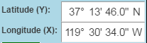
These input controls enable the user to enter the latitude and longitude of a location for which a postmile needs to be identified.
The information for each coordinate can be entered in the degrees, minutes, seconds and cardinal compass point format, or as a signed decimal number of degrees.
The format is determined by the  checkbox that appears below the coordinate
input controls.
checkbox that appears below the coordinate
input controls.
Changing the coordinate values moves the pushpin marker ![]() to the indicated location.
to the indicated location.
In "Line" mode, there two sets of latitude and longitude fields, labeled "1" and "2", and two pushpin markers, ![]() and
and
![]() .
Each set of input fields reflects and controls the position of its associated marker.
.
Each set of input fields reflects and controls the position of its associated marker.
This button finds the postmile closest to the geographic location indicated by the coordinates. A postmile paddle icon marks the location of the postmile, and a line is drawn from the push-pin icon to the postmile paddle icon.
The specification of the postmile found this way is displayed in the controls of the Postmile fieldset.
In "Line" mode, the postmile specifications for the postmiles closest to the two geo-coordinate markers are inserted into the controls for the two postmiles. If the two postmiles lie on the same route, then the pair are validated as a line.
Input Controls (cont'd)
Other Controls

This check box appears above the top left corner of the map window. When checked, additional map layers are made visible, depending on zoom level.
At low zoom levels (when the map covers a large geographic region) county boundaries are drawn in black.
At higher zoom levels, the routes in the linear reference system are drawn in red.
At still higher zoom levels, the calibration postmiles are drawn as green discs, accompanied by the numerical portion of their postmile value (the qualifiers are not shown). Also, at these higher zoom levels the left and right sides of the routes are drawn independently (whether or not the linear reference system aligns the two sides independently). When this happens, the right side of the route is drawn in red, and the left side is drawn in blue.
At very high zoom levels these overlays again become invisible.
Controls & Map Markers
Postmiles
Valid postmiles are represented on the map using markers with the postmile paddle icon ![]() .
.
Clicking on a postmile marker will show the information window for the postmile, and populate the postmile controls with the specification of the postmile at the marker's location.
In "Line" mode, if the marker represents a candidate for the first or second postmile of a line pair, the icon will show the number
![]() or
or
![]() , and clicking on it will populate the controls for the corresponding postmile.
, and clicking on it will populate the controls for the corresponding postmile.
Double-clicking a postmile marker will move the push-pin marker to the postmile's geographic location (and thus populate the geo-coordinate fields with the postmile's location).
Geo-Coordinates
The push-pin icon ![]() marks the location on the map represented by the coordinates in the geo-coordinates fieldset. This marker may be dragged with the mouse to move it to another place
on the map. The geo-coordinate controls will change value to reflect the current position of the marker.
marks the location on the map represented by the coordinates in the geo-coordinates fieldset. This marker may be dragged with the mouse to move it to another place
on the map. The geo-coordinate controls will change value to reflect the current position of the marker.
Clicking on the push-pin marker will determine the recognized postmile that is closest to the location of the marker, populate the postmile controls with it, and validate it
(same as clicking the ![]() button in the geo-coordinates fieldset.) If the location of the postmile is different than that of the push-pin marker, a line will be drawn connecting the two markers.
button in the geo-coordinates fieldset.) If the location of the postmile is different than that of the push-pin marker, a line will be drawn connecting the two markers.
In "Line" mode, the set of postmile controls that is populated is determined by which of the two markers is clicked (they are labeled ![]() and
and
![]() ).
).
Clicking on an open area of the map itself has the same effect as moving a push-pin marker to that location and clicking on it. In "Line" mode, the pushpin marker that is moved and the postmile fields that are populated is determined by the input control that last had focus: moving the focus into any input control for a postmile specification will cause the controls for that postmile to be populated with the postmile that is next found from geo-coordinates by clicking on the map.
How to: Point Mode
With the "Point" radio button selected, the query tool is in "Point Mode", which deals with an individual postmile representing a point geographic location on California's system of highways.To Validate a Postmile
Enter the postmile specification in the "Postmile" fieldset, and click ![]() .
If you entered a valid postmile, a marker with postmile paddle icon
.
If you entered a valid postmile, a marker with postmile paddle icon ![]() will show the location. An information window will also
appear above the marker giving both the postmile specification and the state odometer for the postmile.
The pushpin marker
will show the location. An information window will also
appear above the marker giving both the postmile specification and the state odometer for the postmile.
The pushpin marker ![]() will also move to the location of the postmile, so that the geo-coordinates display will
contain the latitude and longitude of that location.
will also move to the location of the postmile, so that the geo-coordinates display will
contain the latitude and longitude of that location.
If the postmile specification is not recognized by the Postmile Web Service, a message will appear to that effect above the map. In some cases, the web service can identify candidate postmiles. These are valid postmiles that differ from your specification only in the values of one or more qualifiers. When candidates are identified, they are listed in the message above the map, and they are located on the map with postmile paddle icons. You can populate the postmile controls with one of the candidates by clicking on its specification in the validation message (each is a hyperlink), or by clicking on the postmile marker for the candidate on the map. (Clicking either will also open the information window for the postmile paddle marker of the candidate. In conjunction with the Close Infowindows button you can explore the candidates.)
To Determine the Postmile for a set of Geo-Coordinates
Enter the geo-coordinates into the Latitude and Longitude input fields in the Geo-Coordinates fieldset (or drag the push-pin marker to the location on the map) and clickClicking on the map will move the pushpin marker to the click point, and display the nearest recognized postmile with the postmile paddle.
To determine the Geo-Coordinates of a Postmile
Validate the postmile by any of the methods above, then double-click on the postmile paddle. This will move the pushpin marker to the postmile location, and put the geo-coordinates in the latitude and longitude fields.How to:Line Mode
With the "Line" radio button selected, the query tool is in "Line Mode", which deals with pairs of postmiles representing a segment of a route in California's system of highways.To Validate a Postmile Pair
Enter the postmile specifications in the "Postmile" fieldset, and click ![]() .
.
The two postmiles must represent two locations on the same route (this is enforced in the "Components" controls by having only one set of controls for the route.
If you entered two valid postmiles, two markers showing the postmile paddle icons ![]() and
and
![]() will show the beginning and end of your segment, and the route between them will be marked in Sea Green. (Any parts of the route that are no longer under the
aegis of the California Department of Transportation, or that overlap a dominant route in the system, will cause gaps in the marked route.)
will show the beginning and end of your segment, and the route between them will be marked in Sea Green. (Any parts of the route that are no longer under the
aegis of the California Department of Transportation, or that overlap a dominant route in the system, will cause gaps in the marked route.)
If either or both of your postmile specifications are not recognized, then a message to that effect will appear above the map. This message may include candidate postmile pairs that differ from your specifications only in the values of one or more qualifiers. If so, postmile paddle icons will mark the positions of the candidates for each postmile. Clicking on a candidate pair in the message will populate the postmile controls, and pop up the information windows for the corresponding markers. Clicking on a postmile paddle icon labeled 1 or 2 will populate the controls for the corresponding first or second postmile.
To Validate a Segment by Geo-Coordinates
Enter the geo-coodinates for the ends of the segment in the Geo-Coordinates fieldset.
Then click on the ![]() in the Geo-Coordinates fieldset. This will
determine the postmiles for the ends of the segment. Of course, you can also determine the coordinates of the ends by dragging the corresponding pushpin markers.
in the Geo-Coordinates fieldset. This will
determine the postmiles for the ends of the segment. Of course, you can also determine the coordinates of the ends by dragging the corresponding pushpin markers.
To determine the Geo-Coordinates of the Segment Ends
After validating the segment, double-click on the postmile paddle icons shown at each end of the segment to move the push-pin markers there, then read the latitude and longitude displayed
in the Geo-Coordinates fieldset. Alternatively, click the ![]() in the Postmile fieldset. This will revalidate the
segment and move both geo-coordinate markers to their respective postmile locations.
in the Postmile fieldset. This will revalidate the
segment and move both geo-coordinate markers to their respective postmile locations.
Browser Configuration
The Postmile Query Tool has been developed to work with most browsers. However, we can only support the most recent versions of these browsers, and parts of the tool's functionality may not work properly unless certain configurations are set in the browser. The following browsers have been tested:- Google Chrome (version 50.0+)
- Mozilla FireFox (version 46.0.1+)
Within each browser, ensure the following:
- Do not use "Compatibility" mode;
- Do not use graphics hardware acceleration (may not be compatible with Google Maps)